Our River: The Severn
As you
drive north through Hallow you can’t see the river and you are probably quite
unaware you are following an ancient river terrace, carved and formed by ice
and water long ago. The Severn flows along, unseen, at a discreet distance of a
kilometre or so. For many centuries the
river was not only a more important route than the roads but also a vital part
of the local economy and a lifeline to communities near its banks. Huge quantities of heavy and household goods
went not by road but by Britain’s longest river, “the King’s high stream of
Severn” where passage was free with no tolls to be paid.
Transport
and industry
Before the construction of the locks in
1840 the river looked very different, flowing in a series of streamy runs,
rocky shelves and deeper water. If you look at the river below Bewdley you get
an idea of how it used to appear. The effects of tide could be felt as far
upstream as Stourport. Boats, using sail
and man power, transported cargo as far upstream as Pool Quay just below
Welshpool. Bow hauliers, teams of 20 men
harnessed to a tow rope, pulled boats upstream and later, when a tow path had
been constructed in the early 1800’s, barges were pulled by horses. Severn
Trows were flat bottomed sailing vessels, direct descendants of Roman and
Viking river craft. They had been in use at least from the13thC. At around 70
foot long they were, for decades, the largest class of boats in Europe. They
were very numerous along the banks of the Severn from Shrewsbury to Bristol,
numbering around 700 at one time on the Severn. They were used to carry cargoes
of up to 250 tons up the River to Bridgnorth and as far north as the Shropshire
Severn gorge. By transshipping onto to smaller 20 ton boats, vessels could get
as far as Welshpool. Much depended on
the water levels. The winter months were the busiest. At Bevere,
long before the weir and lock were built in the 1840’s, there was a rocky bar
known as Shanty Oak, which hindered traffic when the river was low during
periods of drought. The Camp nearby
provided stabling for horses, food and drink, 2p for bread and cheese and 5
pints of cider or beer for a shilling.
During periods of drought they could wait sometimes for weeks. The bow hauliers, wearing traditional cock
hats, were no doubt the toughest of the watermen. The trowmen were not far behind however and
quite prepared to use violence and intimidation towards any rival carriers on
the river.

Bow
hauliers by Worcester Bridge

Wych barges
carried cargos of salt from Droitwich down the salt canal and down the Severn
to Gloucester. The return trip was
loaded with coal from the forest of Dean.
Wharves and mooring places could be found all the way along the
Severn. The river must have appeared
quite picturesque with the square sails of the trows looking as though they
were sailing through the fields
(Pictured left) One of the last commercial trows on the Severn
Cargoes coming upriver during the 1600s and 1700s included various
English and French alcohols, but especially Spanish wine (arriving even when
Britain and Spain were at war, as the trade was regarded as too important to
allow the war to interfere with it!). Major foodstuffs were imported, groceries
(sugar, currants, tea, spices, etc.), herrings and citrus fruits. A huge
variety of cloths came in, along with skins from hunted or domesticated
animals. Then there were seeds, grains, tobacco, deal boards, earthenware, pipe
clay, soap, metal ware, dyestuffs, coal, pitch, tar, resin, and finally train
oil, a product of whale's blubber, to be used as lamp oil.
Downriver
cargoes were similar in type but not in detail: the main alcohol was cider;
foodstuffs were bacon, cheese, confectionery, honey, and salt. Cloths went
downriver, but not quite of the same type as that arriving. A few animal skins
went as well, but a far bigger trade was glovers’ shreds - the leftovers from
products made in this region. Hops, wheat and malt were the major agricultural
exports, while other items were timber, bricks, earthenware, paper from paper
mills in the Worcester area, ironware, lead and tin ware, and even money as a
cargo.
You could claim that the river fuelled the
surge in industrial activity. River traffic probably reached its peak during
the industrial revolution. But as early
as the 1650’s Andrew Yarranton had opened an iron works near Astley. He used Dick brook to bring barge loads of iron
slag dumped by the Romans at Pitchcroft.
He re-smelted this slag to make household utensils. If you paddle around in Dick brook you will
find lots of chunks of slag from Yarranton’s furnace. The remains of the furnace and smelting works
were uncovered some years ago by a torrential thunderstorm. I was lucky enough to visit the site with
Bill Gwilliam back in 1970 before it was recovered with earth to preserve
it. Holt Fleet Bridge, one of the many
constructions by Thomas Telford, came by boat in sections from Coalbrookdale.
The building of the Worcester – Birmingham and the Staffordshire canals brought
more cargos from the industrial midlands.
Curiously,
the rise of the motor car in the 1920’s, led to an increase in river
traffic. Oil wharves were built in
Worcester at Diglis docks and at Stourport. Tankers became a familiar sight
from the 1920’s until the 1960’s.
During WW2
tanker traffic became important once more.
Jim, the landlord of the Camp, tells me that the
river was as busy as a motorway with tankers Robin, Swallow and Swift carrying
petrol; tugs Victor, Progress, Enterprise pulling butty boats Jack and Jill, King and Queen, with ingots, timber and
chocolate crumb, from Gloucester to Stourport.

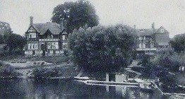
The Camp and Ferry,
1910
Leisure
As well as carrying cargo
the river was a favorite place for leisure activities. After the locks were built there was a huge
increase in pleasure boats. The introduction of early closing day on Thursdays
in the 1880’s enabled workers in shops and offices to take advantage of the
outdoor life. Steam boats plied the river, running excursions or providing a
regular service between towns. There
were huge numbers of row boats as you will see from almost any old photo of the
river. Rowing clubs flourished. Worcester had several boat yards where you
could hire a boat. There were also small houseboats affording more privacy and
protection from rain. A popular weekend
excursion was to row or be rowed upstream and picnic or stop at Camp public
house for refreshment.

People also bathed in the
river at one of the ‘lidos’. At Grimley,
a shallow, sandy stretch became known as the lido or the ‘slip’ and attracted
crowds of people in summer. Many a
Hallow child has learned to swim in the Severn.
Crowds of people came from Birmingham.
Many farmers leased out
plots of land and holiday chalets were built on the river bank. The remains of
these can still be seen. A onetime
neighbour of mine used to be taken by car in the 1930’s to the Camp with his
swimsuit on. He would then swim
backstroke and be picked up a little later at Worcester bridge.

Northwick Slip/Salt Lane
Originally a fordable
crossing point of the River Severn, believed to have been the point at which
Prince Edward (later to be crowned King Edward I) crossed the river on his way
to the Battle of Evesham. This was also
a trading wharf from the medieval period onwards.
There was also a lido at
Northwick where there was another sandy shore. It was probably at the same
location as an ancient ford.
You can see from a map
that a lane runs down the bank on the Hallow side and joins up with Old
Northwick lane. This ford was part of
the old salt way from Droitwich, a very ancient crossing.
Fish
The Severn has also long
been an important source of food.
Migratory fish, salmon, eels, lampreys and shad came up from the sea as
well as the many other fish that abound in the river. Fish
weirs were controlled and jealously guarded by the church. Bishop Ealdred in the middle of the 11th
century gave to the priory of Worcester fisheries at Hallow, known in the 13th
century as Chiterling and Scadewell.
Nobody is sure of their exact whereabouts. They may have taken the form
of a fish weir that channelled water so that a net could be lowered to capture
salmon running upstream. They have been
in the form of a series of pools behind Hallow Park, the hollows of which can
still be made out today.
In 1346 the
prior at Hallow made complaint against men of the town of Worcester that they
“not only attacked him and his monks with bows and arrows and tried to burn
down their priory, but they also fished in his fishery at Hallow and hunted and
carried away hares and rabbits from his warren there”.
There is
just an echo in the phrasing of this last incident of the antipathy that Hallow
dwellers still feel towards Worcester and its influence. In the 1700’s salmon were so abundant that
apprentices could not be given them to eat more than three times a week. Many
families made their living by netting – 24,000 fish annually in 1910. But by 1929 legislation was introduced to ban
netting above Tewkesbury as stocks began to dwindle. Today the annual catch is numbered in a few
hundreds.
Fords and Ferries
Also
important along the river were the fords and ferries. It was important and
sometimes dangerous to get across the Severn.
Down stream of Hallow is Kepax ferry; at Barbourne, the Dog and Duck;
opposite Pitchcroft, the Grandstand ferry to take you across to the races. At the Camp they ran their own ferry to bring
leisure strollers across from, Bevere, a popular Sunday walk. Further upstream near the Salwarpe entry
boats and cargo had to cross to the far bank because the towpath on the west
side finished here. Somewhere near here
too was the ford used by the funeral cortege carrying the body of Prince Henry
from Ludlow in 1502. “It was at
Hallow Ford” writes W. Gwillam “that in
August 1265, Edward, Prince of Wales, deceived Simon de Montfort, by pretending
to march his army up the west bank to Ludlow but, under the cover of darkness,
he returned to cross at Hallow Ford and confront de Montfort next morning at
the fatal battle of Evesham. This must have been a busy crossing in days past,
for the fields on both sides of the river have depressions from old brickyards,
but there is no record of a ferry here for a very long time.” You can still see
the place where the ford would have been on a map. The track running eastwards opposite Hallow
Mount links up with Northwick Lane on the other side of the Severn. Also known
as Salt Way. In living memory there was another
popular bathing place here known as Northwick Lido showing how shallow the
river is at this point.
 |
| Kepax Ferry |
 |
| The Dog and Duck |
Wartime
During WW2
the Severn became important as a natural barrier, vital to national
defence.
Measures
were taken to prevent the enemy crossing the river. Provision had already been made to move
government and monarch to the safety of western Britain and the river Severn
was designated as a stop line against possible German attack either from the east
or from the west. Bevere lock was
guarded by the South Staffs home guard equipped with a machine gun which they
had mounted on an old spoil heap left from when the lock was dug in 1840. The men’s toilets at the pub were also a
defence post with loopholes facing up Camp Lane. One of the long hams just downstream of the
pub had a series of wooden posts at intervals to prevent enemy planes from
landing. What a change of purpose from
the days when in the 1840’s these fields attracted huge crowds to the Camp
House races. Further upstream on the
east side of Holt Fleet Bridge you can see an old pill box which still has its
Hotchkiss 6 pounder gun mounting. The
gun would have been trained to cover advance from the west. The front of the
building was meant to be a disguise for a café!
The bridge was also protected by slots in the road to take iron
girders. These can still be seen when
the bridge is resurfaced. On the west side of the river, just up the hill but
no longer visible, there was a fougasse
fuelled from a petrol tank set into the hillside. This device could project a sheet of flame 30
feet across the road thus providing a deterrent to attack from the west.

The WW2
pill box at Holt Fleet Bridge. In the
background is the fishing pond belonging to the pub. The gun inside was trained to protect the
western approaches to the bridge in case the Germans had landed in Wales –
seems unlikely! The disguise as a café
is reminiscent of Dad’s Army.

The river
still flows, and floods regularly, in the natural course of things. There are still some pleasure boats, rowers,
fishermen and walkers but no hauling of boats, very few ferries and no
commercial activity. The resurrection of
the Droitwich salt canal, when completed, will no doubt greatly increase boat
and pleasure traffic creating a peaceful alternative to the increasing
congestion of the roads.

Iron slag from an ancient blast furnace
These
pieces are similar to those that can be found in Dick brook. Feel the weight of them. They came from the
river Rea at Upper Forge below Cleobury.
The forges must have been very noisy places when at work. The vicar of a village nearby records being
able to judge the direction of the wind from the noise of the forge.

A 1795 engraving looking westwards from Worcester. The boat on the left is a passenger wherry, probably a ‘water taxi’ to Hallow.

A very picturesque scene painted by John
Sinclair-Black C 1880. Masts and sails
had to be lowered to go downstream. The steam boat goes through easily but if
the river were in flood all boats would have a problem.

An 1829 scene near Diglis docks showing
the newly built tow path. The boat on
the left is a covered passenger wherry.

Circa 1906 a scene near Ironbridge. The tow rope is attached high on the mast to
avoid snagging on the bank vegetation.

Stuck on the bridge!
A Severn trow during the 1880 floods. The bridges often brought water transport to
a halt. If you look at the middle arch
of Worcester Bridge today you will see a lot of damage done by boats over the
years.

Scene below Bewdley at Blackstone rock showing
how the river might have been before below Stourport before the construction of
the locks. Here the river flows over red
sandstone bedrock with alternating deep pools and shallows.
Kepax ferry at Barbourne not far from the
site of the old Worcester waterworks.
Also called Bailey’s boat after the name of the ferryman.
The Dog and Duck ferry (c 1908). There was also a wharf here and goods were
taken up the steep path by donkey. The
name of the pub derives from the cruel pastime of clipping ducks’ wings and
unleashing dogs to catch them.
All manner of boats could be hired for a
day of longer on the river. These motor
launches could take parties of twelve for picnic or camping trips upriver.


A men’s boating party at Camp c 1911. A rather crowded boat! Upstream just below Bevere weir you can see a
houseboat moored – perhaps a fishing party.

A picture postcard view of the Camp from Bevere. A stroll by the river from Bevere was a favourite weekend venue in Victorian times. The pub had its own ferry to take people across on demand. The gardens sloping down to the river were also an attraction but have long since been washed away by floods.

Grimley
Lido in the 1930’s
A busy day
at the beach at Grimley lido! At one
time the farmer charged tuppence and there were refreshments sold. The river is
shallow here. The old towpath had to change to the opposite bank. It was probably also the site of an ancient
ford crossing of the river.
People
flocked from the city on sunny summer weekends to enjoy the delights of a dip
in the river. Swimmers and sunbathers
travelled by buys, cycle, and Shanks’s Pony, or for the few lucky ones, the new
family saloon car. Picnics were enjoyed
too.
I am
greatly indebted for most of these pictures to The River Severn a Pictorial History by Josephine Jeremiah 1998,
and to Bill Gwilliam’s Severn Ferries and
Fords in Worcestershire -1982.
William Barratt